In six and half centuries the almshouse which became the Charterhouse has inevitably seen many changes, from the major upheavals of the Reformation and the Civil War to the gradual adaptations to the society in which it is set. The most obvious changes have been to the buildings. But there are huge gaps in our knowledge.


The only image of the buildings in this period comes from John Cook's 1882 history of the Charterhouse. It's a bit of a puzzle since the perspective is odd. We can't tell how many inmates it would have housed. The number of residents certainly fluctuated through the years. The original charter stipulated that there should be 13 poor men and 13 poor women, but that was the only clause in the charter which was routinely ignored. There were often far fewer than 26 inmates, especially during the post-Reformation years when the Masters were left to their own devices and were sometimes either lazy or corrupt. There is no record of whether the 17th century rebuild was an opportunity to expand the hospital's capacity.

The rooms in Bourne Wing followed the style of those in the main block. They were architecturally of their time but took no account of the fact that their occupants were all elderly and many were infirm. Their very high ceilings, with windows to match, made such matters as window-cleaning and hanging curtains impossible without help. Half of the accommodation was on the first floor, with their residents often trapped, in their later years, by their inability to negotiate stairs. There were few handrails. Unfortunately, all the subsequent extensions followed the same pattern.
 There was plenty of room to expand further. On the south side was a huge garden behind the Master's house, but this was, apparently, sacrosanct. There was space to the north but no money, until, in 1840, a chunk of the Hessle lands was sold to the Hull and Selby Railway Company for over £506 (c. £30.5k today). With nearly £1,060 in the bank (£64k) the Master, Thomas Dikes, got permission for a new block of 12 rooms, each measuring 15ft x 12 ft, which were ready for occupation in 1845. Six of these were intended for widows of of deceased residents, but in the end only three of them were needed for that purpose.
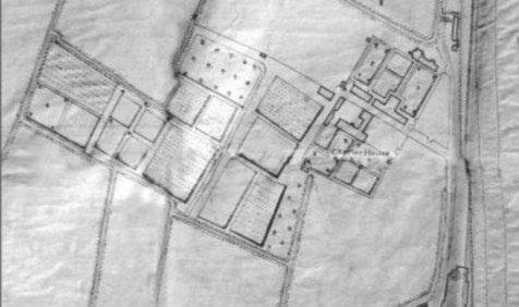
This 1853 map shows the boundaries of the property had been reached and no more accommodation could be built (without using the garden). In 1863 the plot shown on the map as Clappison's Square was bought for £1,510 and plans drawn up to build 32 rooms and two washrooms on the site, in stages. To fund this, part of the lands at Hessle was developed; eight "villas" were built and leased out. By July 1867 twelve new rooms at the Charterhouse were ready for occupation. There were various proposals for more rooms, and it is not clear which were actually built.


This drawing by F S Smith is from the same period, 1884.
However, plans had been under way since 1881 to expand further. William Thomas Dibb, the local brewer, had offered the money but wanted to be anonymous, and it was several years before his name was revealed. Numerous proposals were put forward, including building in the Master's garden, and at the same time concerns were raised at the poor state of the existing buildings. It was August 1885 when plans were finally approved for 14 new rooms. They were completed in 1886.

The whole complex was left empty in 1941 as some bomb damage prompted the evacuation of the residents. It deteriorated as time went by, and was not made habitable again until 1948. But the patching up had laid bare how poor the accommodation was. The conditions became scandalous and in 1960 there was an effort at modernisation. Most rooms were merged into 2-room flatlets and electric sockets were fitted. However, it was clear that this was inadequate, and a complete redevelopment was needed.
In the 1970s money for housing was becoming available. The first use of it for the Charterhouse was the construction of a "new house" in the south west corner. The records are sparse on this, but it appears to have been built in 1975. There are two flats and, as always, it is a 2-storey building with no provision for a lift or even a stair lift. Government money was available only to Housing Associations, so the Charterhouse became an HA, a move which made little difference to the day-to-day running but which enabled it to secure the grants for a complete redevelopment. The 1780 building could not be demolished because of its listed status, and local planners decided that the 1804 Bourne Wing should also be given that status and spared - a mistake in the view of many. All the Victorian buildings, however, were reduced to rubble in 1978 and, in their place, modern flats erected.

All this reconstruction could have been an opportunity for a long-lasting solution to the problems inherent in 2-storey buildings, but it was not taken. Maintenance of the old buildings is, of course, expensive.
The Charterhouse has been in existence for well over 6 centuries. The future may well see further evolution of its buildings.


